
Winter storm to bring heavy snow to East Coast this weekend
The year's first significant winter storm in the eastern U.S. is expected to bring heavy snow to more than a dozen states this weekend.
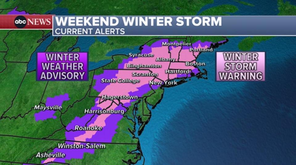
Winter storm warnings and winter weather advisories continue throughout much of the Northeast on Saturday.

Overall, there is a wide swath of projected 6-12 inches across many interior portions of the Northeast. Some of the highest snow totals will be found in the higher elevations of New England, where more than a foot is likely.
There remains uncertainty in snowfall for some regions. In Connecticut, for example, snow totals will likely rise the farther north you go from I-95. Eastern Massachusetts is another area that may have a sharp gradient of snow totals, with some getting a lot and some getting barely anything.
"The combination of heavy, wet snow and gusty winds from northeast Pennsylvania through much of southern and central New England will result in difficult travel with some power outages and tree damage," the National Weather Service warned. "Gusty onshore winds may lead to minor flooding along the Mid-Atlantic and southern New England coasts during the Sunday morning high tide cycle."
Timing the storm
The storm has been making its journey across the country during the last few days, drenching the south Friday while dropping several inches of snow in states including Arkansas, Missouri and Illinois.
It is bringing rain to cities including Washington, D.C., and Baltimore and other parts of the I-95 corridor south of New York City.
Up to 6 inches of snow has already been reported in parts of southwestern Pennsylvania and 3 inches in Pittsburgh.
Snow has also moved into the New York City area. There may be an initial "thump" of moderate to heavy snow before the inevitable change to a wintry mix of snow and rain near the coast for Long Island and NYC.
By 8 p.m. ET, conditions are likely to begin deteriorating across parts of New England as the snow moves in. While this storm is not a blizzard, low visibility can be problematic in any snowstorm, so drivers are urged to use caution.
MORE: Winter storms: How to prepare and everything else you need to know
Snow is expected to continue across much of the Northeast into the overnight hours. Along coastal areas, any snow on the ground may become slushy as a change to rain occurs. The heaviest snow is forecast to fall overnight.
By Sunday morning, there will likely be lingering areas of snow in much of the Northeast, while the daytime will bring a few spotty snow showers that gradually taper off.
The storm is expected to move out of the Northeast by Sunday evening, with a few lingering light snow showers scattered in the region.
Next cross-country storm
Meanwhile, the next cross-country storm is coming ashore on the West Coast with heavy snow, rain and large waves. The Bay Area is on alert for waves up to 20 feet on Saturday.
In the Pacific Northwest, up to 20 inches of snow is possible in the Cascade Mountains.
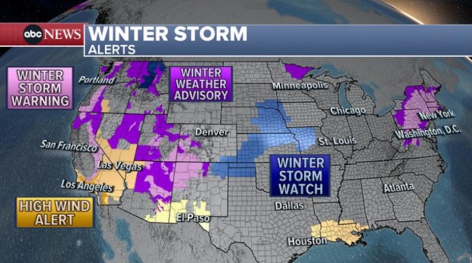
As this storm surges east across the country, there is a chance for severe weather along the Gulf Coast on Monday. There is a chance for damaging winds and tornadoes from Texas to Florida -- including in Houston on Monday afternoon and New Orleans and Mobile, Alabama, on Monday evening, then into Tallahassee, Florida, early Tuesday and up to Wilmington, North Carolina.
There is also a risk of flash flooding with very heavy rainfall.
The northern, cold side of this storm will bring a potential crippling snowstorm to the Midwest with more than 6 inches of snow possible along the I-80 and I-70 corridors on Monday and Tuesday along with wind gusts up to 40 mph.
The storm is forecast to be in the Northeast by Tuesday evening, just 48 hours after the last storm left, with warmer temperatures leading to rapid melting of the recent snowfall accumulations and heavy rain. All of this leads to a risk of flooding in the Northeast.
Winter storm to bring heavy snow to East Coast this weekend originally appeared on abcnews.go.com

