
UK weather maps pinpoint when summer will roar back - with 28C heatwave blasting away drizzle
Brand new weather maps have revealed that the UK is set to be hit by a 28C heatwave later this month.
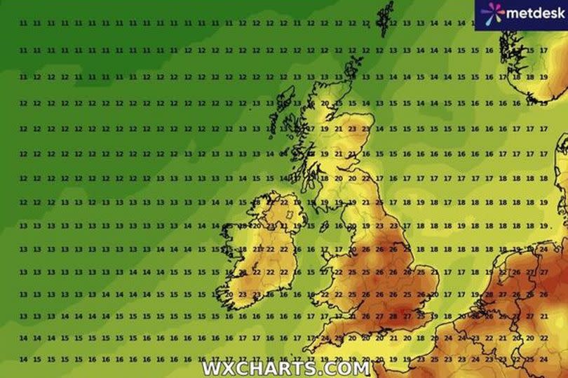
The maps indicate that temperatures will peak around July 15, particularly in the south and southeast. Areas around the South Downs and south of London are expected to experience the highest temperatures, reaching between a toasty 27C and 28C.
In areas such as Canterbury, Dartford, Dover, Swindon, and Reading, located further east and west, temperatures will slightly drop to between 25C and 26C, but still perfect beach weather. Devon and Cornwall will also see slightly lower temperatures, with lows of 17C and highs of 25C.
High temperatures will also be felt in the Midlands and northern parts of England with cities like Manchester, Liverpool, Birmingham and Leicester seeing temperatures around 26C, while Newcastle and Middlesbrough will be slightly cooler at 23C.
Scotland will experience much cooler temperatures, peaking at 22C in urban areas and dropping to between a chillier 13C and 17C in coastal towns and villages. Wales will also be cooler than much of England, with temperatures falling to 16C on the coast and rising to 25C further inland, reports the Express.
This trend of England being warmer than Wales or Scotland continues into July 16, with high temperatures persisting in the south and southeast, but cooler conditions in the west, southwest, and north. Sun worshippers will rejoice at news that the mercury is set to soar close to 30C on July 16 in England, but for Scottish residents temperatures are the very opposite, falling to as low as 11C on higher ground.
The UK's summer has been a rollercoaster of weather extremes, from scorching 30C heatwaves to torrential downpours that have marred April, May, and parts of June.
Despite the unpredictable weather in June, the Met Office has declared it as one of the driest months on record. It was cooler and drier than usual with rainfall 29 percent less than the "long-term meteorological average".
The forecast for July suggests more of the same, with the Met Office predicting a mix of warm and wet conditions between July 16 and July 30 in its long-term forecast.
They explained: "There has been an emerging trend towards more settled and possibly warmer weather in the run up to this period, which appears to have been brought forward from the middle of the month.
"This may well continue through to the start of this period with drier conditions a little more likely than normal. However, as we go through the rest of the month, the latest information suggests that a return to cooler and more unsettled weather is now slightly favoured.
"The forecast signals are all rather weak and conflicting, so confidence in a definitive story at this range can be nothing other than very low."
Here's the Met Office forecast until Saturday, July 6, with confirmation that it will feel "pleasant in any sunshine."

Wednesday
Wednesday will be a cloudy and damp day for many, particularly in the north of the UK. The northwest will turn especially breezy and it will feel cool under the cloud and rain.
Outlook for Thursday to Saturday:
Thursday will be brighter with blustery showers. Winds will become lighter on Friday with outbreaks of rain in the south.
Saturday will see sunshine and showers. Temperatures will remain on the cool side.

