
These shocking aerial images show the threat of climate action
A bird’s-eye view
ROBERT ATANASOVSKI/AFP/Getty Images
Different vantage points have the power to give us new perspectives. And that’s certainly true of these extraordinary aerial images. Depicting everything from dried-up waterways such as Great Salt Lake in the US to disappearing glaciers, burnt-down forests and cities shrouded in smog, these photographs show the devastation of the climate crisis all around the world.
Gloucestershire, England, UK

Gideon Mendel Corbis via Getty Images
Nicknamed “the day it rained forever”, on 20 July 2007 two months' worth of rain fell in just 14 hours in Gloucestershire, southern England. The extensive flooding brought total havoc to the region: 5,000 buildings were damaged, 135,000 homes were without drinking water for up to 17 days and damages cost an estimated £50 million ($69.1m). Pictured here is a small hamlet that was badly affected by the flooding, which is set to become more frequent and more intense due to climate change.
La Florida, Bio Bio Region, Chile
Christian Miranda/AFP/Getty
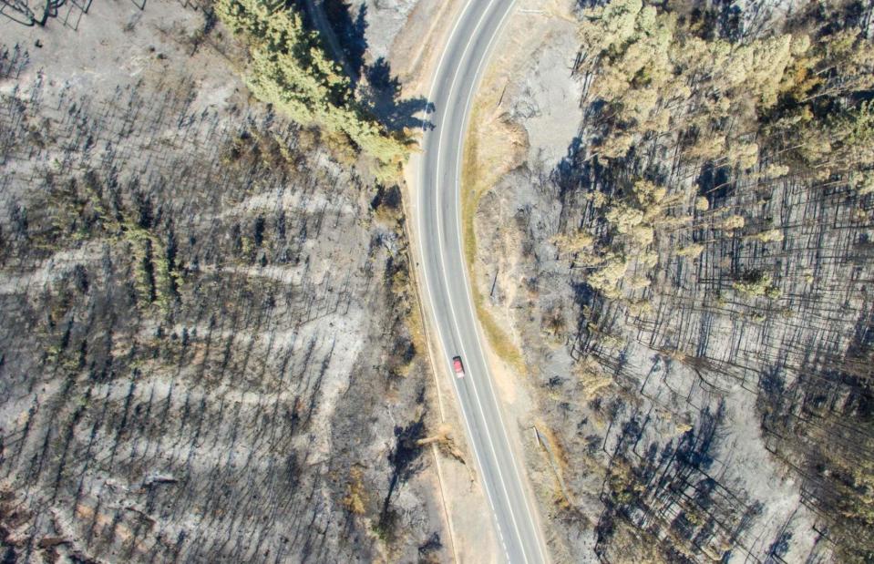
Chile was engulfed by devastating wildfires in January 2017, leaving swaths of desolate-looking forests such as this one in La Florida. The fires began in the hillsides of Valparaíso, just after New Year, before sweeping across the south, burning a total area the size of Delaware. According to members of the fire brigade, poor preparation for climate change and monocultures (large areas of the same crop) worsened their impact.
Yabelo, Ethiopia
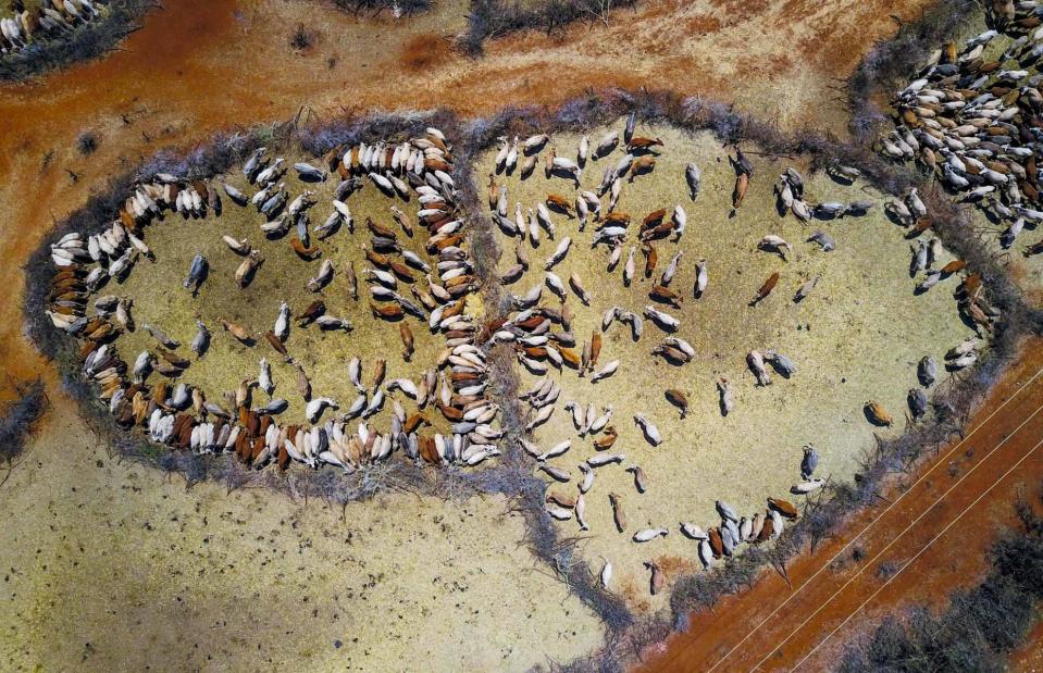
Eric Lafforgue/Art In All Of Us/Corbis via Getty Images
In 2016, one of the strongest El Niño events ever recorded led to a severe drought in Ethiopia, meaning that almost 18 million people had to receive emergency aid. In 2017, when the country was still struggling with its impacts, it was devastated by a further brutal drought. Pictured here, cows, suffering due to the drought, have been grouped together to receive food, provided by the Ethiopian government.
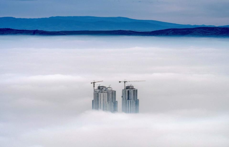
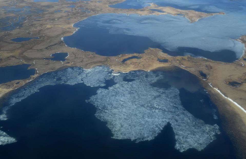
Skopje, Macedonia

ROBERT ATANASOVSKI/AFP/Getty Images
In 2018, Skopje received an unwelcome accolade: it was named Europe’s most polluted capital city. The Macedonian capital, shown here from Vodno Mountain in 2017, is often shrouded in a stinky smog, with levels of the harmful pollutant PM10 exceeding EU limits for 202 days a year. It’s even thought that dirty air could be responsible for 4,000 premature deaths annually in North Macedonia.
Lake Okeechobee, Florida, USA

Joe Raedle/Getty Images
Notice the greenish swirls on the surface of this lake? While they might look pretty, they’re actually the sign of a serious ecological problem. The bright green toxic algae that appears seasonally in Florida’s Lake Okeechobee comes from fertilisers from nearby farms, and has multiplied due to warmer temperatures, intense sunlight and more frequent rainfall. And the problem is only set to worsen in coming years due to climate change.
Furtwängler Glacier, Mount Kilimanjaro, Tanzania
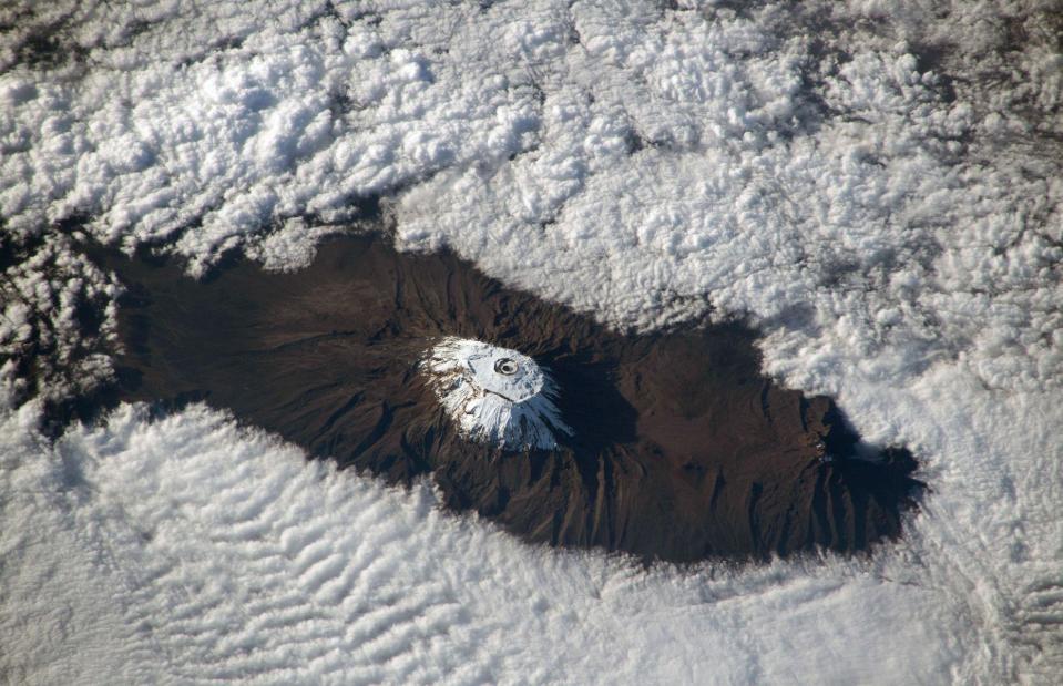
NASA J Marshall/Tribaleye Images/Alamy Stock Photo
The mighty Mount Kilimanjaro is Africa’s highest peak at 19,340 feet (5,895m). Yet the glaciers which once covered it are shrinking fast – so fast, in fact, that renowned ice climber Will Gadd had to cancel his plans of scaling them, because the Messner route he’d planned to take was rendered impossible. Pictured here from the skies in 2018, the Furtwängler Glacier lost an enormous 70% of its mass between 2014 and 2020, so that only thin walls of ice remain.
Bozo, Bamako, Mali

MICHELE CATTANI/AFP via Getty Images
In late September 2018, the Malian capital, Bamako, and surrounding areas became flooded following heavy rain. Regions lying on the banks of the Niger River, such as the village of Bozo (pictured) were worst affected. Severe floods hit the region again just eight months later, killing 15 people and affecting around 300 households. Climate change is causing rainy seasons to be more severe and unpredictable, according to the International Committee of the Red Cross’ Lemba Bisimwa, who oversees the organization’s work in Mali.
Quinhagak, Alaska, USA
MARK RALSTON/AFP via Getty Images
Permafrost – constantly frozen soil, rock and sediment – is found beneath almost 85% of the land in Alaska. But with the dual threat of warming temperatures and increased rainfall, the stuff is melting fast, causing some Alaskan villages to relocate. In the Yupik Eskimo village of Quinhagak, seen here from the skies, large chunks of land have been eroded by the Kanektok River on one side, while the sea is claiming land on the other.
Lake Puzhal, Chennai, India
Atul Loke/Getty Images
The largest reservoir supplying water to Chennai, one of India’s biggest cities, almost completely dried up in June 2019. Lake Puzhal, along with the city’s three other major reservoirs, were hit by water shortages caused by a delay in the onset of the monsoon season. This left poorer residents dependent on drinking unsafe water collected from makeshift wells, while richer people were able to have water imported from nearby provinces. The frequency of heatwaves in India is also on the rise; a study published by the University of Cambridge in April 2023 said "Indian heatwaves could cross the survivability limit for a healthy human resting in the shade by 2050."
Corfo Lagoon, Patagonia, Argentina
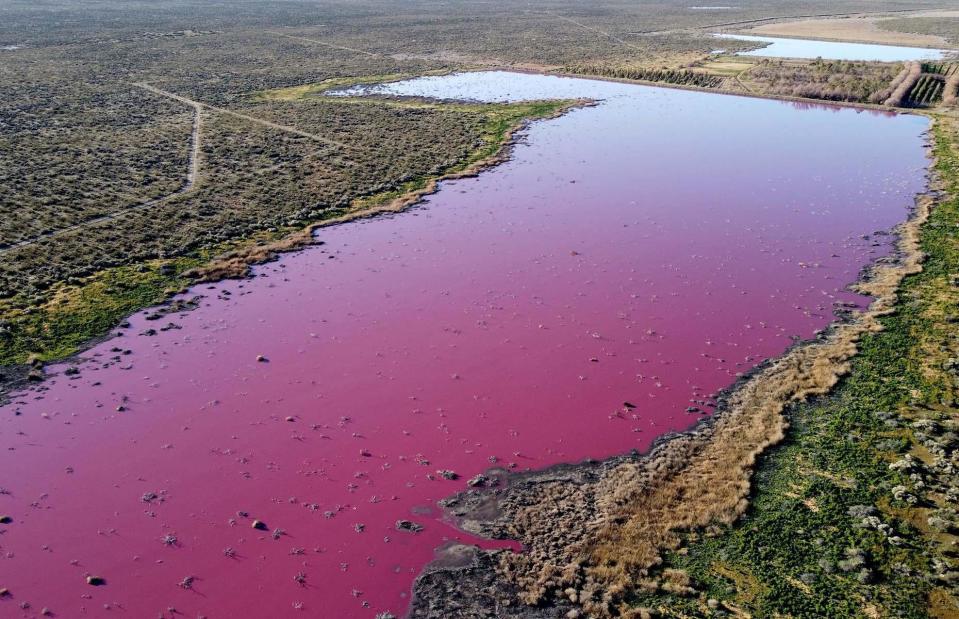
DANIEL FELDMAN/AFP via Getty Images
The bright pink hue of this lake is the sign of an ecological disaster. According to environmentalists, Corfo Lagoon in Argentinian Patagonia gained its sickly colour in July 2019 due to sodium sulfite, a product used in fish factories which ran into the water. Activists say that the chemical should have been treated before being dumped in the lagoon. Meanwhile, local residents have complained of a foul smell and proliferation of insects near the lake, which are also linked to the pollution.
Kivalina, Alaska, USA

Joe Raedle/Getty Images
The far-flung Alaskan village of Kivalina sits on a thin strip of land, bordered on one side by the Kivalina Lagoon and on the other by the Chukchi Sea. Yet as the Arctic warms at twice the rate of the global average, causing the ice sheet to melt and sea levels to rise, the Inupiat village is being eroded on all sides. In fact, it could be underwater as soon as 2025.
Amazon Rainforest, Para State, Brazil

JOHANNES MYBURGH/AFP via Getty Images
Few could forget the devastating fires that ripped across the Amazon rainforest in 2019. In August that year, Brazil’s National Institute for Space Research (INPE) reported that there were more than 80,000 fires across the country, almost an 80% increase on the same period of the previous year. The dry conditions which helped the fires to spread were linked to warming in the North Atlantic Ocean, which was drawing away moisture from the continent.
Beaverhead-Deerlodge National Forest, Montana, USA

Chip Somodevilla/Getty Images
The usually lush green pine trees of Beaverhead-Deerlodge National Forest in southwest Montana have turned ghostly grey in recent years, as this image from September 2019 goes to show. And there’s an unexpected culprit for the mass die-off. As winters have become milder due to climate change, mountain pine beetle numbers have ballooned, and the insects have ravaged forests across western America. On top of that, drought has weakened the trees, making them more vulnerable to insect invasion.
Funafuti, Tuvalu
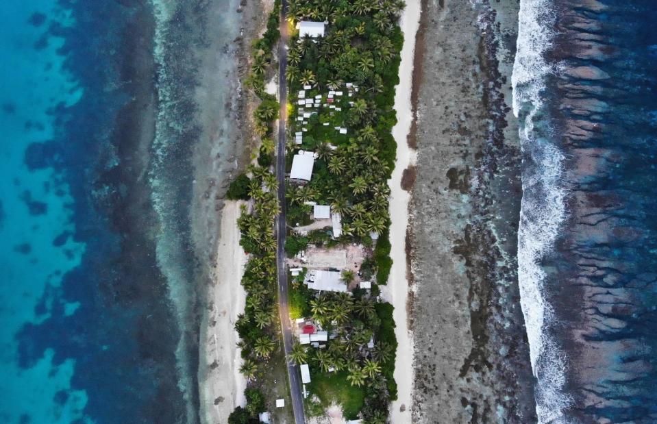
Mario Tama/Getty Images
The country of Tuvalu is situated on a narrow coral atoll in the Pacific Ocean, with no part of the island being more than 15 feet (4.5m) above sea level. This makes it extremely vulnerable to sea level rise. Pictured here in November 2019, the island nation, which covers 10 square miles (26sq km) and is home to around 11,000 people, is predicted to become uninhabitable within 50-100 years.
Harz mountains, Clausthal-Zellerfeld, Germany
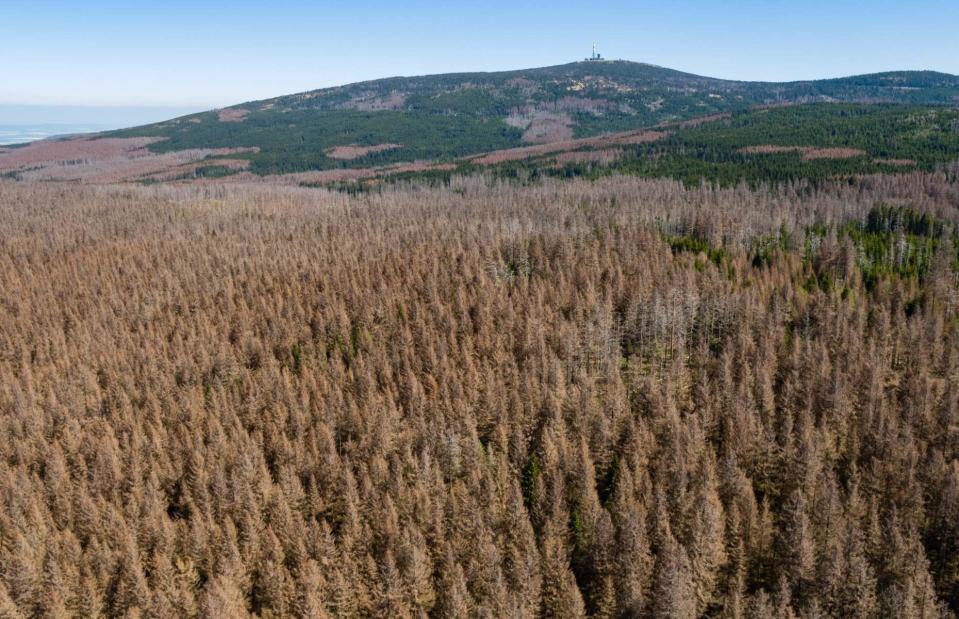
Jens Schlueter/Getty Images
Northern Germany’s Harz mountains are usually cloaked in verdant green come summer, or a pristine white covering of snowfall in winter. But one colour they’re not used to seeing is this parched brown hue, a result of unusually dry conditions, warm temperatures and insect infestation, which are becoming increasingly severe each summer. In 2020, when this photograph was taken, more trees died than ever before in Germany, while just one in five had an intact canopy (a sign of a healthy tree).
Jiujiang, Jiangxi Province, China

HECTOR RETAMAL/AFP via Getty Images
In this shocking aerial image, houses in the city of Jiujiang are completely surrounded by water following severe flooding in July 2020. Located on the banks of the Yangtze River, the settlement was one of many victims of that year’s flooding, which affected 63 million people and was thought to have killed more than 200. According to climate scientists, rainstorms will become more frequent and intense due to climate change, meaning floods are set to become even more severe in the future.
Longyearbyen, Svalbard, Norway
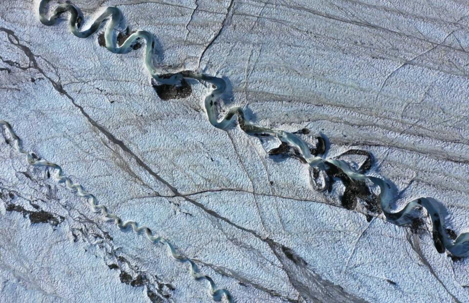
Sean Gallup/Getty Images
The glaciers on the Svalbard archipelago, located between Norway and the North Pole, are some of the most northerly on the planet. But they’re also some of the most vulnerable to climate change, according to research published in the journal Nature Communications, due to their lower elevation and domed shapes. In this photograph, taken from a drone, meltwater winds a channel through the ice during an unseasonably warm summer in 2021.
San Nicolás de los Arroyos, Argentina

Tomas Cuesta/Getty Images
In the Paraná River delta region of Argentina, terrifying fires scorched wetlands in the summer of 2020. With their carbon-rich soils, exposed by lower water levels in the river and made extremely dry by a lack of rainfall, these areas have the perfect conditions for fire to spread quickly. According to government data, almost 20,000 hectares of wetlands were burnt.
Happisburgh, Norfolk, England, UK
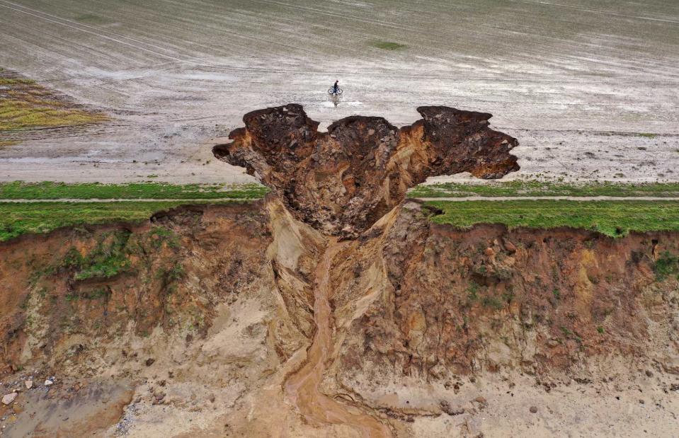
Christopher Furlong/Getty Images
Shocking aerial images captured in January 2021 show just how badly the coastal village of Happisburgh has been hit by erosion. This area of the Norfolk coastline loses on average seven feet (2m) of land to the sea each year, and the heavy rainfall of the winter of 2020-2021 caused huge chunks of the cliff to fall off. Yet while flooding can be controlled, it’s harder to turn the tide on erosion. In the UK, sea levels have risen by six inches (15cm) since 1900, but sea level rise could reach four feet (1.12m) globally by 2100 if nothing is done to curb emissions.
Oran, Algeria
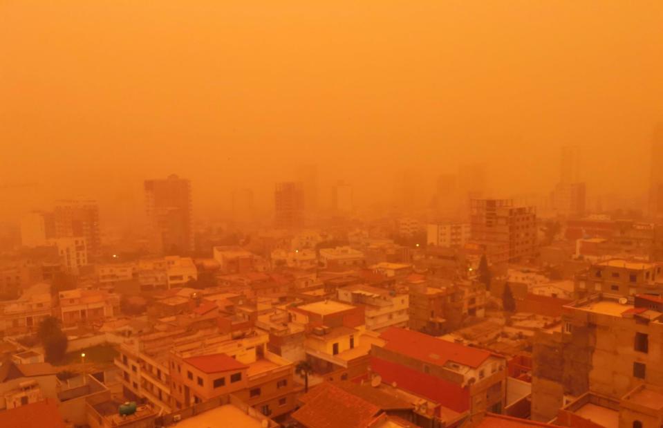
AFP via Getty Images
Skies turned bright red over Algeria in February 2021 as a result of an intense sandstorm. The sand was kicked up from the Sahara desert by strong winds, before traveling into Algeria and then north into European mountain ranges, including the Pyrenees and Alps. Although sandstorms are a natural occurrence, dry conditions caused by climate change are making them more frequent and intense.
Suesca Lagoon, Colombia

Diego Cuevas/Getty Images
Seen from the skies in March 2021, you can see how cracked and barren the surface of Suesca Lagoon looks after a year of very little rainfall. Dried-up riverbeds like this could become a more common sight due to climate change, especially in drier regions which are more sensitive to changes in rainfall.
Neve Zohar, Dead Sea, Israel

Gil Cohen Magen/Xinhua/Alamy Live News
At eight to nine times saltier than the ocean, the Dead Sea is notoriously one of the most saline places on Earth. In fact, the salt content is so high you can almost sit on its surface. But for the past few decades, its water level has been dropping by more than three feet (1m) a year, caused partly by a lack of rainfall, which has fallen by around 10% in the region since 1950. In response, it’s becoming saltier, sinkholes are forming in their thousands, and salt formations like these are appearing on its surface.
Lake Isabella, California, USA
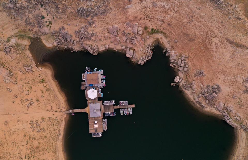
David McNew/Getty Images
California experienced its driest year in a century between 1 October 2020 and 30 September 2021. In the Kern Valley, this led to the shrinking of Lake Isabella, which received just a fraction of the seasonal snowmelt it would usually have in spring. In October 2021, officials announced they were considering restrictions on activities like car-washing, watering lawns and offering water in restaurants to attempt to combat the drought.
Gorny Ulus, Sakha, Siberia, Russia
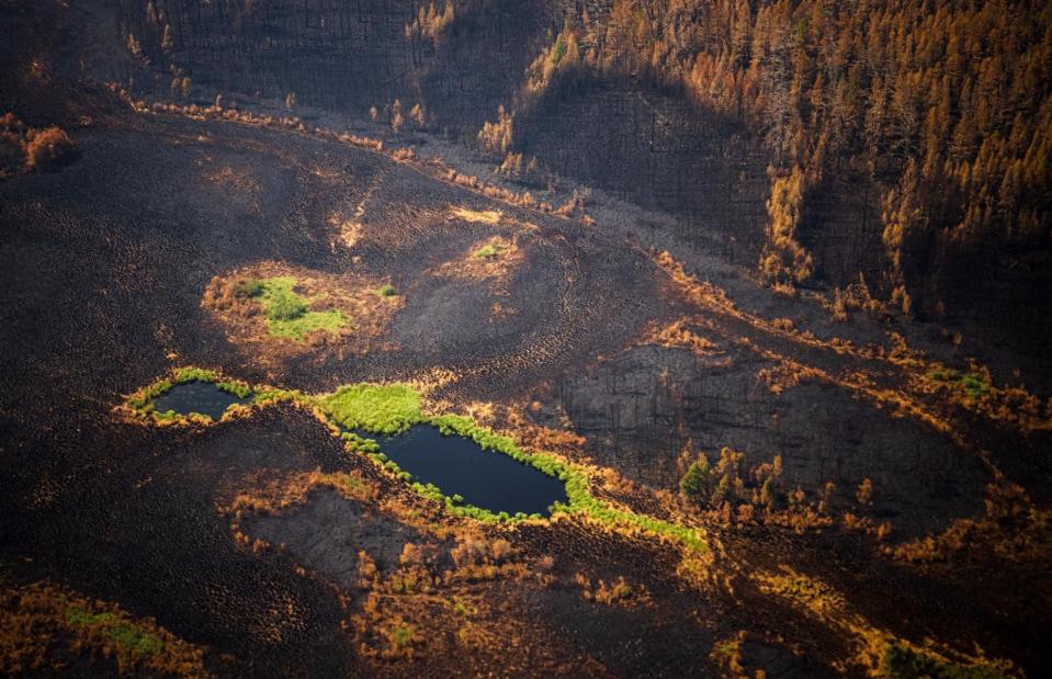
DIMITAR DILKOFF/AFP via Getty Images
Scenes like this became widespread after Russia was hit by its worst fire season in modern history in summer 2021. While wildfires are a natural occurrence each year, the blazes which ripped across the country from June destroyed more than 18.16 million hectares of forest and released a whopping 970 megatons of carbon into the atmosphere. Smoke from the Siberian wildfires even reached the North Pole for the first time ever, according to NASA.
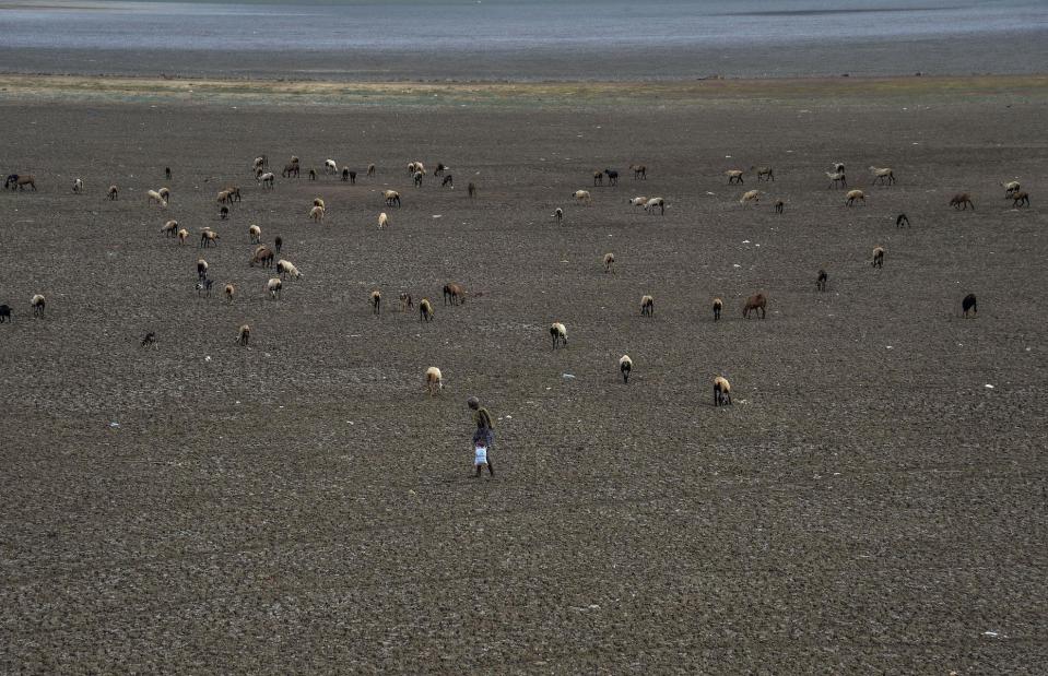
Hof, Iceland
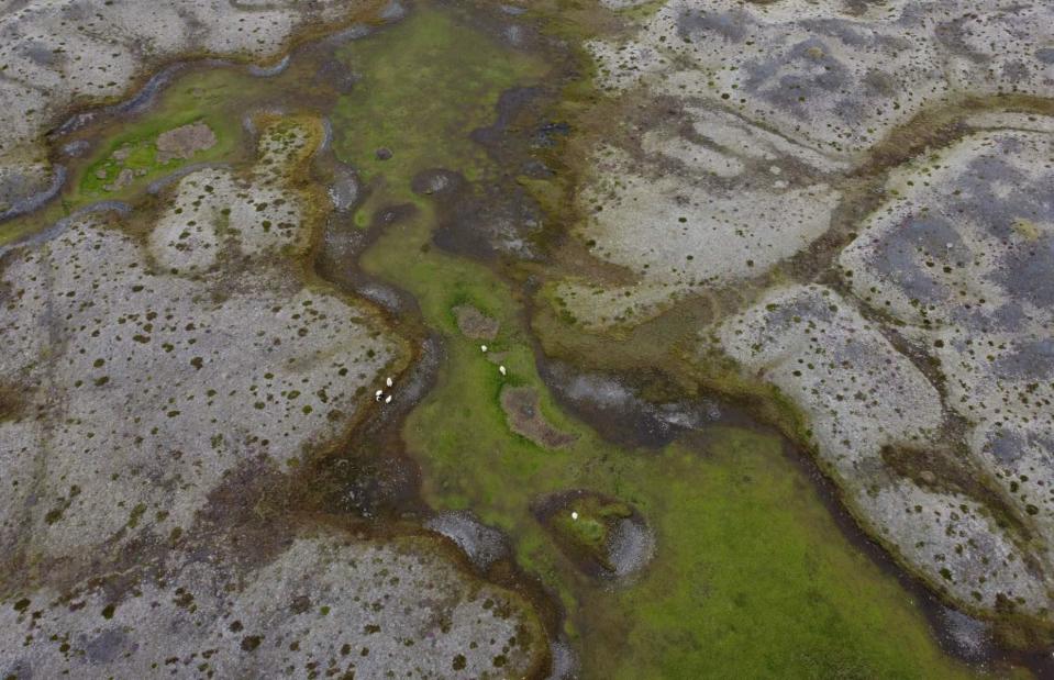
Sean Gallup/Getty Images
Can you make out those tiny white specks in this picture? They’re actually sheep, and although the land they’re grazing on looks green, it’s surrounded by a barren sand and gravel-covered surface. That’s because the nearby Breidamerkurjokull glacier is retreating due to a warming climate, with ice calving (the loss of chunks of ice) increasing rapidly in recent years. Between 2019 and 2000, Iceland lost 290 square miles (750sq km) of glaciers.
Lake Oroville, California, USA

JOSH EDELSON/AFP via Getty Images
In August 2021, California’s second-largest reservoir, Lake Oroville, reached such low levels that the hydroelectric power plant had to be shut for the first time ever. Dismal scenes such as this became commonplace after the state suffered its driest year in a century and Lake Oroville reached a low point of 643.5 feet (196.1m) above sea level, its lowest point since 1977. In stark contrast, the reservoir filled to full capacity in 2023 after a period of historic rain and snowmelt.
Ilulissat, Greenland
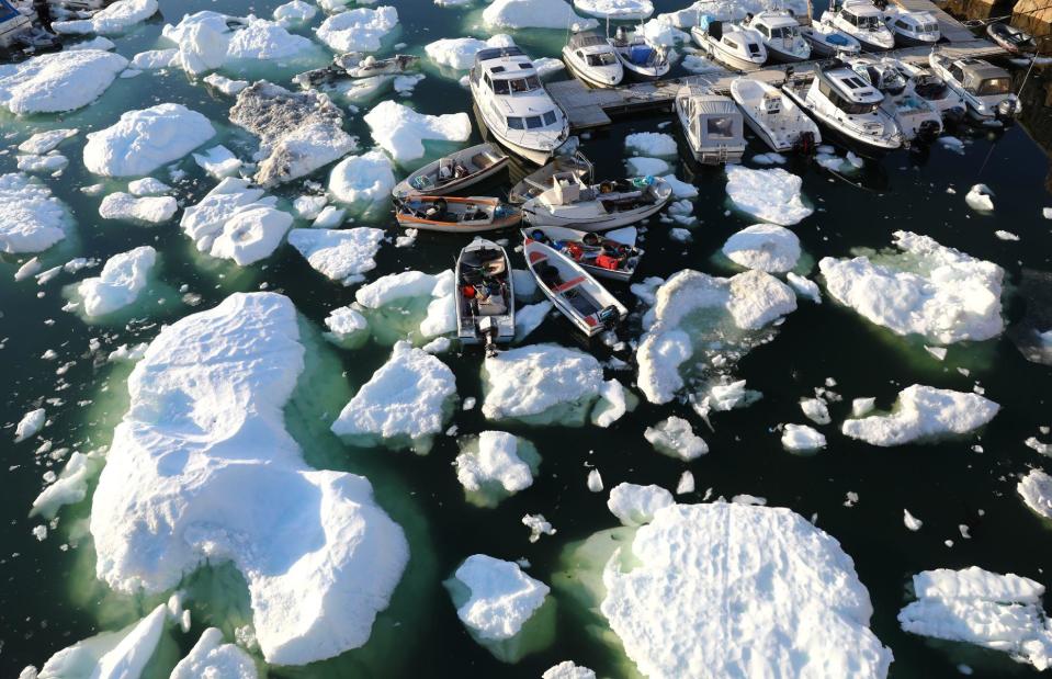
Mario Tama/Getty Images
With rain falling on the Greenland ice sheet for the first time in history in August 2021, the ice sheet had two significant “melt events” during summer. Seasonal melting is a normal occurrence, but in 2021 it was especially severe: on 28 June, 340,000 square miles (881,000sq km) of the ice sheet broke off, making it the seventh-largest melt event in history. Meanwhile 336,681 square miles (872,000sq km) melted on 14 August. Pictured is the town of Ilulissat, where chunks of broken ice could be seen floating around boats in the harbor.
Lahore, Pakistan

ARIF ALI/AFP via Getty Images
In 2020, Pakistan’s capital was ranked as the most polluted city in the world by the US Air Quality Index. Air pollution is usually at its worst in Lahore in winter (October-February), when farmers burn their crops and the smoke becomes trapped by pollutants in the air. Other contributors to pollution include smoke from brick kilns, dust from building sites and the large-scale loss of tree cover, which means less carbon is being absorbed. Shown here in October 2021, you can see how poor the visibility is due to the thick cloak of smog covering the city.
Lake Mead, Nevada/Arizona, USA
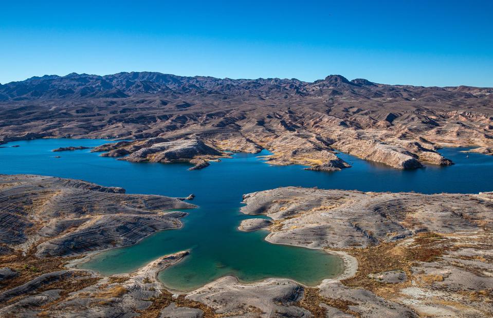
George Rose/Getty Images
Technically a reservoir rather than a natural lake, Lake Mead is the body of water contained by the Hoover Dam, created in 1935 to supply water to the American West. Yet the reservoir, which straddles the Arizona-Nevada border, reached dangerously low levels in summer 2022. A combination of drought, plus higher rates of evaporation due to warming temperatures, led Lake Mead to reach a lowly 1,044.03 feet (318m) above sea level in June. This put immense stress on the water supply, as well as electricity, given that water must run through the dam in order to produce hydropower.
Great Salt Lake, Utah, USA
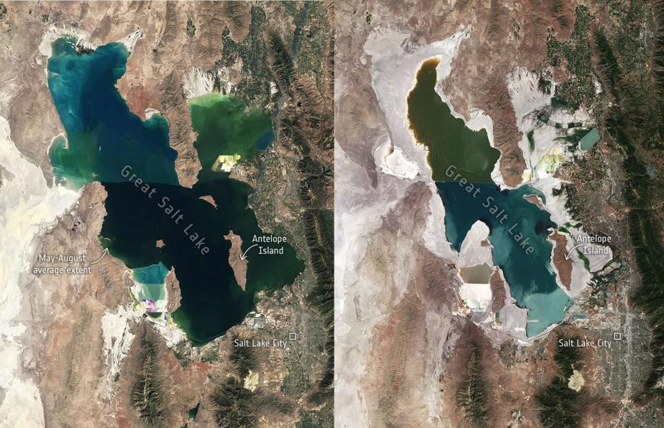
USGS/ESA
An icon of the state of Utah that gives state capital Salt Lake City its name, this enormous saline lake is much saltier than the ocean and is so buoyant that swimmers can easily float. A crucial habitat for mammals and migratory birds, climate change-fuelled drought and local water usage have caused the lake to recede at an alarming rate. The Great Salt Lake reached its lowest volume ever recorded in November 2022, at just 4,188 feet (1,277m). These satellite images, released by the European Space Agency, show the lake in 1985 (L) and in 2022 (R), having lost almost half its surface area.
British Columbia, Canada
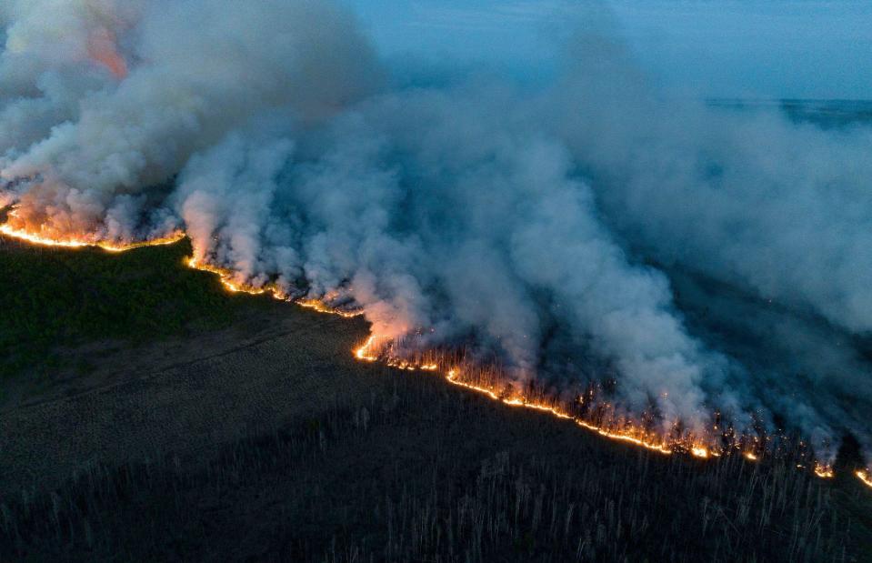
Xinhua/Alamy
Unprecedented wildfires incinerated huge swaths of Canada during the first half of 2023, affecting several provinces and belching smoke into the air which reached as far as the European continent. In what has turned out to be the country’s most devastating wildfire season on record, 3,056 blazes burned between January and June, scorching around 20 million acres of land. While each wildfire cannot be directly linked to the climate crisis, hotter and drier conditions caused by the warming of the planet have made Canada’s forests like tinder boxes. In this chilling image, fires can be seen sweeping across the northwest region of British Columbia.
Glossop, Derbyshire, England, UK

Christopher Furlong/Getty Images
The planet-warming event El Niño returned with a vengeance in 2023, with US scientists confirming its arrival in June. So far, it has contributed to countries such as the UK enduring their hottest Junes since records began, as well as spiking global temperatures so severely in July that the world saw possibly its hottest week in the record-keeping era. El Niño, hand-in-hand with humans’ negative impact on the climate, will set in motion further periods of runaway weather patterns, like heatwaves, flooding and drought, as well as ecosystem damage. Pictured here are the extremely low water levels of Woodhead Reservoir, on the edge of England’s Peak District National Park.

