
The 10 best walks in the Peak District

White Peak and Dark Peak; their names sound like two warring kingdoms on Middle Earth. One can be found in the lush, green south of the Peak District, with its valleys, broadleaved woodlands, wildflower grasslands and limestone caves, while the other dwells in the northern uplands, famous for its windswept moors and gritstone crags.
In reality, these are the two main sections of the Peak District National Park, which, having become the UK’s first National Park in 1951, is set to celebrate its 70th birthday this year. Despite their rather different characteristics, they both make for inspirational walking.
White Peak offers gentler walks in limestone valleys, with Dovedale and Monsal Dale among the most popular destinations. The footpaths are well maintained and there are atmospheric villages with limestone cottages, narrow lanes, and cosy country pubs (sadly closed right now).
Dark Peak, as the name suggests, has tougher walking terrain with its crags, tors, and boggy peat uplands, but its rewards include landscapes like Stanage Edge, the longest ridge of millstone grit in England, with its stunning views over the heartlands of Britain. At its core, heading north from the village of Edale, is the Pennine Way, Britain’s first National Trail, opened in 1965.

Kinder Scout, Dark Peak’s moorland redoubt, secured its place in history as the scene of the legendary mass trespass in 1932 which pioneered the Right to Roam movement and served as the catalyst of the creation of the National Parks we know and love today.
Here are some of the best walking routes to be found in the history-making Peak District National Park.
Kinder Scout
Follow the Pennine Way from its start in Edale to the site of the 1932 mass trespass which pioneered the Right To Roam movement.
Distance: 11 miles
Map: Peak District (Dark Peak) OL1
Route: From Edale, climb ‘Jacob’s Ladder’ and follow the Pennine Way to Kinder Low along the Kinder Plateau. At Kinder Downfall (waterfall), head south-east to Grindsbrook Clough and back to Edale.
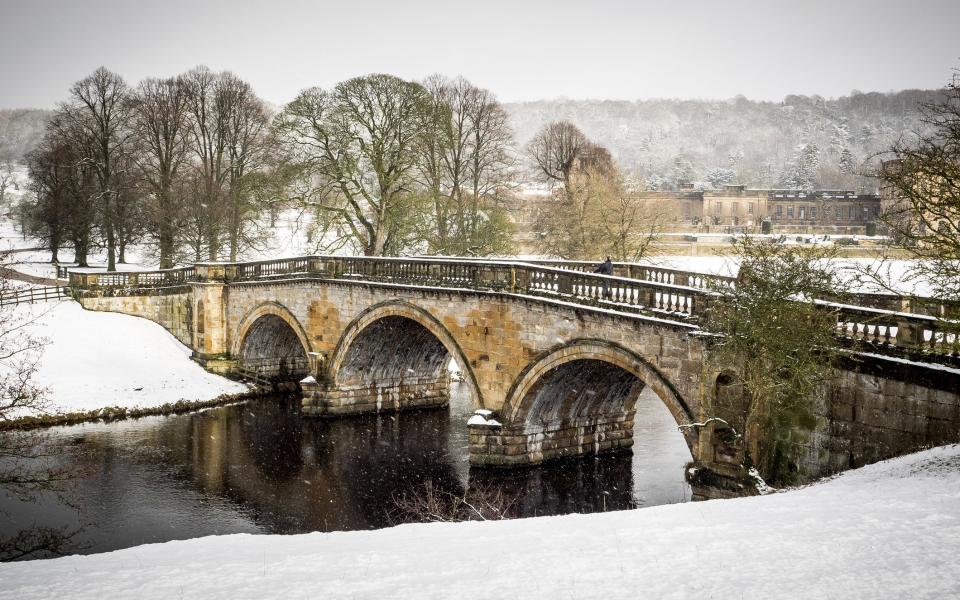
Chatsworth Estate Circular
Chatsworth House, home to the Dukes of Devonshire for 500 years, is a must-visit local attraction (though currently closed). This walk is the best way to experience the estate from both the woods above the house and the park in front, designed by Lancelot ‘Capability’ Brown.
Distance: 7 miles
Map: Peak District (White Peak) OL24
Route: From Beeley, climb to Beeley Hilltop and through Stand Wood. Head south to the Derwent River Heritage Way and follow the path at the front of the house back to Beeley.
Derwent Edge
Follow the banks of the scenic Ladybower Reservoir up through woods to Derwent Edge’s surreal gritstone outcrops with their magnificent views. This walk combines easy woodland pathways with exposed moorland ascents.
Distance: 11 miles
Map: Peak District (Dark Peak) OL1
Route: From Ladybower House head north-west along the east bank of the reservoir. At Hancock Wood, climb to Lost Lad Cairn and follow Derwent Edge south-east back to the inn.
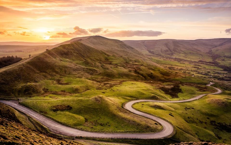
Mam Tor
An iconic Peaks landmark, Mam Tor means ‘Mother Hill’ and dominates the skyline west of Castleton. From its peak, the epic view takes in Kinder Scout, Stanage Edge and Derwent Moors.
Distance: 11 miles
Map: Peak District (Dark Peak) OL1
Route: From Castleton, head west to Mam Tor. To enjoy the effort of the climb, stay high and head north-east to Lose Hill before looping back through Hope to Castleton.
Padley Gorge and Burbage Rocks
Enjoy a combination of White and Dark, from the gentle woodland paths in Padley Gorge to the high moorland landscapes of Hathersage Moor, Burbage Rocks and the Longshaw Estate.
Distance: 13 miles
Map: Peak District (Dark Peak) OL1 and (White Peak) OL24
Route: From Grindleford station and its famous café (currently closed) follow Burbage Brook through Padley Gorge and east onto Millstone Edge. Cross Hathersage Moor to Burbage Rocks and down through the Longshaw Estate to the station.
The Monsal Dale Trail
This family-friendly trail follows a disused railway line. Paved and suitable for walkers, cyclists and horse-riders, its numerous landmarks include six illuminated tunnels and the limestone valley of the River Wye.
Distance: 9 miles
Map: Peak District (White Peak) OL24
Route: Start at Coombs Road Viaduct, near Bakewell, past Hassop station, Headstone Viaduct, Cressbrook Mill, and Litton Mill to Blackwell Mill, Chee Dale.

The Roaches and Dane Valley Way
A gritstone ridge famous for its wildlife and folklore, Roaches highlights include Lud’s Church, an eerie moss-covered chasm which is said to have sheltered Robin Hood.
Distance: 9 miles
Map: Peak District (White Peak) OL24
Route: From the car park under the Roaches, climb the ridge and follow the path to Danebridge, looping back along the Dane Valley Way to Forest Wood. Climb the escarpment to Lud’s Church and Roach End with a detour to Hen’s Cloud on the return.

Stanage Edge
Few keen walkers (or climbers) can resist an ascent of Stanage Edge, which, at four miles, is the longest ridge of millstone grit in England. The views from the top over the Derwent and Hope Valleys are among the best in the national park.
Distance: 8 miles
Map: Peak District (Dark Peak) OL1
Route: From Hathersage, climb to Stanage Edge and along the ancient packhorse route towards Sheffield. Keep going to the High Neb trig point before turning back.
Dovedale Valley
Dovedale is a National Nature Reserve made up of ancient ash woodland, wildflower-rich grassland, and a valley full of wildlife. Footpaths follow both sides of the river with footbridges at both Ilam Rock and Milldale for shorter or longer walk options.
Distance: 11 miles (Milldale option)
Map: Peak District (White Peak) OL24
Route: From Ilam, follow the River Manifold to the River Dove and track north along the valley to Milldale. At Dovedale Wood on the return leg, cross Bunster Hill back to the start.
Reader Service: View our pick of the best walking tours

