
Why do shipwrecks appear on in-flight maps?
![The in-flight route map features countries, cities, and, er, shipwrecks - Science Photo Library (Science Photo Library (Photographer) - [None]](https://s.yimg.com/ny/api/res/1.2/2QnWszNjFNGnjK8vzp32Ag--/YXBwaWQ9aGlnaGxhbmRlcjt3PTEyNDI7aD04Mjg-/https://media.zenfs.com/en-GB/the_telegraph_818/d8f26652fe648bd7e59fd9c0e654a7ff)
Depending on how your flight is going - and whether you are engrossed in the latest Ryan Reynolds rom-com/action movie, or asleep with your head bumping against the window - you may, at some point, have found yourself gazing at your seatback screen, and the digital map which shows the progress of your plane towards your destination.
For the most part, there is usually little - beyond the dreary realisation that you are still somewhere near Frankfurt, when you could have sworn you were crossing the Channel - to retain your attention for long. There are the major urban dots on the ground below - Paris, Berlin, Amsterdam and their ilk. There are the less obvious locations - Aachen always seems to crop up on any flight over Germany; Chartwell is sometimes marked as you begin your descent into London. And there are the occasional "landmarks" on the seabed - a ridge here, an oceanic trench there. All largely unremarkable. Back to Mr Reynolds and his latest tussle with the opposite sex and/or an international villain.
But what is this in the corner of the screen? It's an evocative name, with a year in brackets. Could it be? Surely it can't? Yes, it seems to be the location of a shipwreck.
If you have ever spotted this curious quirk - many flight maps have them - you have probably had three subsequent thoughts. The first will be that crash sites - even if they are maritime, rather than aviation-related - are an incongruous thing to put directly in front of plane passengers who might be of a nervous disposition. The second might be to wonder why they are listed on flight maps, and the third to ask who put them there.
The answers to those two questions are surprisingly simple, and can be boiled down, respectively, to - "because it's interesting", and "an American technology company".
Many airlines' flight-map systems (including those operated by British Airways, American Airlines and Ethiopian Airlines) are created by Rockwell Collins, a multinational firm based in Cedar Rapids in the US state of Iowa, whose engineers have hit upon shipwrecks as an inventive way to add points of interest to an otherwise featureless section of a plane's journey - the long miles over water. As Clint Pine, a programs manager for the Midwest corporation put it when he was asked to explain the concept by Conde Nast Traveler in 2017: "When travelling over the ocean, there are often large portions of the flight where only water is visible. Rockwell Collins Airshow [the map system] includes shipwrecks and other undersea items so that passengers can be informed about items they are flying over - but cannot visually see."
So there you have it. Shipwrecks are marked as an alternative to Ryan Reynolds as a time-displacement activity - and are not supposed to give nervous flyers palpitations.
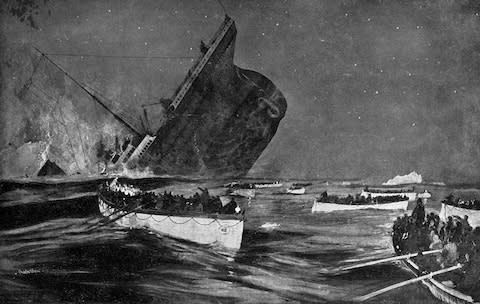
Regular flyers to America may have noticed that the final resting place of the Titanic is generally marked on the North Atlantic portion of flight maps - a tragic, universally understood tale that needs no re-telling 107 years after the event. But what of the less-known wrecks which also pop up briefly on seatback TVs? Do they have fascinating stories of their own? The following five vessels, often identified on flight maps, all do.
Stora Kronan
Wreck location: The Baltic Sea
When did it sink? 1676
Reason for sinking: War
You have to go back to the gun-smoke chaos of the 17th century and the many fights between European powers to hear the tale of this Swedish warship - which was lost in action against Danish and Dutch forces during the Battle of Öland on June 1 1676. The Kronan's demise was strangely similar to the sinking of Henry VIII's flagship the Mary Rose in the Solent 131 years earlier. The kingpin of the Swedish navy, Kronan was one of the world's largest seagoing vessels when it was launched in 1668. And much like its Tudor predecessor, its departure to the ocean floor owed as much to reckless navigation as to enemy fire - it capsized while making an overly sharp turn in heavy waters (and was dispatched to the deep when its gunpowder magazine exploded, blowing off its bow). The wreck lies 26 metres down, four miles east of the coastal hamlet of Hulterstad on the Swedish island of Öland. It was discovered in 1980 by Anders Franzén, a Swedish marine archaeologist, after a 30-year search of the seabed. Several of its muscular cannons (and other artefacts) can be seen at the Kalmar County Museum (kalmarlansmuseum.se), a short journey to the west on the Swedish mainland.
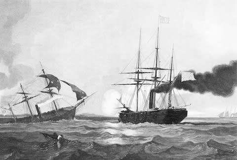
CSS Alabama
Wreck location: Off the Normandy coast
When did it sink? 1864
Reason for sinking: War
The American Civil War has been pored over endlessly by academics and amateur historians, but one facet of this bitterest of conflicts has been rather lost in the details - its overspill into European seas. Step forward the strange case of the CSS Alabama, a Confederate sloop which lies, somewhat improbably, in 60 metres of water just off Cherbourg. It was built in Birkenhead and launched in July 1862 - designed to be an attack dog that would harry Union ships in the Atlantic rather than defending the coastline of the rebel South. And it did so with great success for two years, prowling the Caribbean and the Gulf of Mexico, and sinking the Union steamer USS Hatteras just off (the Texas island of) Galveston in January 1863. But it suffered the same fate a year later, having returned east across the ocean, and put into Cherbourg for repairs. The Alabama was boxed in by the USS Kearsarge - and having charged out of port to do battle, was holed in less than an hour by its enemy's superior firepower (on June 19 1864). Its remains were happened upon by Circe, a French Navy mine hunter, in 1984.
RMS Douro
Wreck location: Near Cape Finisterre, Spain
When did it sink? 1882
Reason for sinking: Collision
Poor seamanship and procedural failure did for this British liner, which gave 17 years of service to the Royal Mail Steam Packet Company between its launch in 1865 and its ignominious end on a clear spring night in 1882. On the April 1 of that year, the Douro embarked on the last leg of a longer voyage, which had taken it north from Buenos Aires and along the Brazilian coast prior to an overlay in Lisbon. Ninety minutes late in departing for Southampton, it had just left Spain's north coast behind it when it came, at full speed, into the path of a Spanish steamer. The Yrurac Bat was more than two miles away when it was spotted under the light of a full moon - but a breakdown in communications between the deck and the bridge meant that the captain, Ebenezer C. Kemp, did not notice the problem until a collision was unavoidable. The Douro was rammed on its starboard flank, suffering two fatal gashes, and plunged into 457 metres of water within 30 minutes of the coming-together (taking the unfortunate Kemp with it). The Yrurac Bat fared no better, slumping to the seabed immediately afterward with the loss of 53 lives (to go with six in total on the Douro). Survivors were rescued by another British steamer, the Hidalgo, and taken to the nearby Galician port La Coruna.

SS Egypt
Wreck location: The English Channel
When did it sink? 1922
Reason for sinking: Collision
The SS Egypt had survived a troubled two decades - ploughing a lone furrow between Tilbury and Bombay (Mumbai); being requisitioned as a hospital ship in the First World War - before its sad moment of destiny on May 20 1922. A liner owned and operated by P&O, launched in 1897, it was sailing south through the Channel when it encountered the French steamship the Seine in heavy fog, 32 miles off the Brittany coast. Captain Andrew Collyer had slowed the Egypt to a near-halt due to the poor visibility, but this did not save it, as the Seine's reinforced ice-breaking bow ripped into its port side. The end was swift - the Egypt slipping under in less than 20 minutes. A bid to salvage the wreck - or, at least, the £1million in gold and silver bullion (about £56million today) in its hold - was put into motion almost as quickly. The ship was found in 170 metres of water in 1930 - although it would take five years of repeat dives and careful extraction before the whole precious cargo had been brought to the surface.
HMS Edinburgh
Wreck location: The Barents Sea
When did it sink? 1942
Reason for sinking: Scuttling
The ocean floor is littered with disembowelled wrecks of the Second World War, and HMS Edinburgh had as fascinating a history as any of them. Launched in March 1938, it had barely left the Firth of Forth before its first date with the Luftwaffe (on October 16 1939) - which saw it sustain minor damage. It was involved in the hunt for Germany's totemic battleship the Bismarck (although not its sinking). And it was deployed as a convoy ship, taking aid and supplies to the Soviet Union, in 1941 and 1942. It was here on April 30 1942, two days after it had left the Arctic port of Murmansk, that the Edinburgh met its initial tormentor, the German submarine U-456 - which dispatched torpedos into its starboard flank and its stern. This was enough to disable, but not destroy, the British vessel - which attempted to limp back to harbour under sustained attack. It was eventually abandoned by its crew, and scuttled, on May 2 - although it took a heavy barrage of "friendly" fire to complete the job. Then came the afterlife. The Edinburgh was carrying about £1.5million (about £69million in 2019, adjusted for inflation) - in the form of 465 gold ingots - and the British government wanted it back. Salvage would take four decades. The wreck was discovered in 245 metres of water, 150 miles north of the Russian coast at 72°N 35°E, in April 1981. By the September, 431 of the ingots had been recovered (with 29 of the remaining 34 being brought up in 1986). This delicate operation was made "easier" by the fact that Edinburgh was a near-replica of HMS Belfast - the D-Day veteran whose retirement as a museum ship on the Thames made assessment of the sunken vessel's lay-out simpler.

