
How Ordnance Survey maps were brought to the masses 100 years ago

In 1918, at the conclusion of the First World War, Charles Close was knighted. The honour bestowed on the colonel was recognition for the work the Ordnance Survey, of which he had been director general since 1911, had done in helping the Allies win the war.
Ordnance Survey - commonly known today as OS - had always been a military institution. It originated from George II’s desire to better understand the Scottish Highlands, so that his generals might root out hiding Jacobite dissenters in the wake of their failed uprising.
In 1791 the OS was made a formal body and tasked with mapping southern Britain, starting at Hounslow Heath. In the century that followed the great and the good of the British army helped chart specific areas of the country under the watchful eye of the War Office.
But Close, though a military man, knew the maps had potential beyond the battlefields.
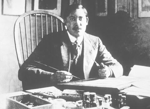
In 1919 he hired Ellis Martin as the Ordnance Survey’s first full-time cover artist and tasked him with selling the “one-inch” (to the mile) maps to the Great British public, so launching the leisure maps that have become so synonymous with outdoor adventures in the UK. The first map illustrated by Martin went on sale in June of that year, a century ago this month.
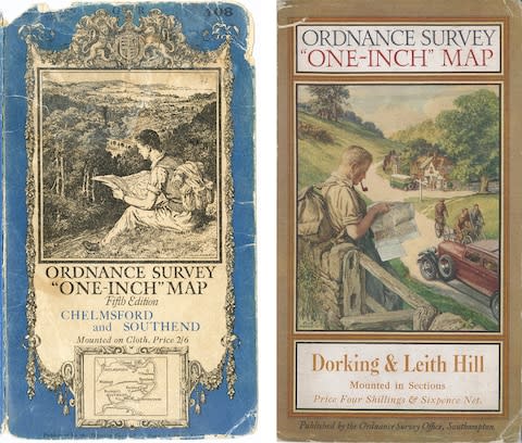
“It was certainly a watershed moment for the OS,” explained map historian Dr Yolande Hodson. “If you appreciate that up until the end of the First World War, OS had produced their maps in very plain colours with black lettering that soon got very dirty at the WH Smiths book stands at stations, and then we had this wonderful coming together of mapping and commercial art. Ellis Martin produced some of the more gorgeous, stunning covers, very much of their period, very evocative of a now lost landscape.”
In an era of Instagram filters and photoshop trickery, it is hard to imagine such an impact being made by a chap drawing map covers, but view the OS products pre- and post- Martin side by side and his impact becomes immediately clear.
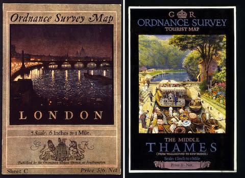
The early covers were gloomy and purely functional: coat of arms, location covered, price. Martin’s were alive, aligned with the interwar belief that the British countryside was the lungs of the people, the nation’s playground. A typical front might show a bucolic setting painted in colour, while at its centre a young hiker pauses outside a country pub, rucksack on back, pipe in mouth, checking his map as a motorcar trundles past.
“The covers were a sort of canny melding together of the walker, the cyclist and the chap who liked to travel by car and stop off at the local pub,” said Dr Hodson. “Sales went up straight away.”
With little wiggle-room for travel expenses, Martin, who had fought in the war and was more used to sketching marshy landscapes to aid the movement of heavy artillery, was often expected to draw his covers from imagination, the purse strings of the OS held tight by post-war austerity. “He must have justified his salary,” said Hodson. “He certainly brought the OS to the fore – at the time it wasn’t really innovating, it was keeping up.”
Ordnance Survey didn’t break new ground with its covers – rivals such as John Bartholomew and Son were already dominating the leisure market with similarly creative designs – but the nation’s mapping agency was transformed by Martin.

“Soon, as far as selling maps goes, the OS was ahead of its time,” says John Paddy Browne, former OS surveyor, editor and historian and author of Map Cover Art. “Martin was designing his own alphabets. Everything on an Ellis Martin cover was done by him, including the letter. It was exhilarating. He was doing things that had never been done before, and the results were immediate.”
Browne, who worked at the OS for 38 years until retiring in 1994, said that the annual reports at the time showed a huge swell in sales, while the Government was happy, too, that the tourist maps were encouraging the public to explore the great outdoors.

The 20 years Martin worked for the OS were not of note solely for his designs. “During the inter-war years, when Martin was in full flight with his brush, the maps he was illustrating were showing some of the fastest development this country has ever experienced,” says Dr Hodson.
“Everyone likes to be an armchair traveller and with these maps you can not only travel over the countryside, but you can go back 100 years and read the landscape in the aftermath of the First World War.
“They show the beginning of the urban sprawl, the proliferation of footpaths and bridleways, and golf courses, and the expansion of road networks.”
Despite annual revisions, and eventual mapping of the entire country, technology paled in comparison to what’s on offer today.
“The maps were beautiful things,” says Browne, “but sometimes they were hopelessly out of date. In 1981 I was a draughtsman working on the Humber estuary when we reached a cut-off date for publication. There was no sign of the bridge on this map, even though it was already open to traffic. It would have taken a small effort to pen in the bridge, even as a skeleton structure, but my boss just said get on with it and the map went out without it.”
Today, the OS runs a tighter ship, having evolved to focus resources both on physical products as well as developing digital sales, apps and augmented reality. But there’s no doubting that even the most recent paper maps come tinged with nostalgia. And for that we owe a debt of gratitude to Ellis Martin.
What are your memories of using OS maps? Share your experiences and stories of favourite maps in the comments below

