
Hiking trails set to open beside the world's most hostile border
Hikers will soon be able to explore the infamous demilitarized zone that divides North and South Korea.
This month, the South Korean government approved plans to construct three walking trails within the "DMZ" buffer, which is 2.5 miles wide, 160 miles long and has divided the two nations since 1953. The first is scheduled to open at the end of April.
Visitors will be required to wear bulletproof vests, which doesn’t sound particularly conducive to a relaxing stroll.
Why are they doing this?
In September 2018, an inter-Korean agreement was made with the UN to turn the DMZ into a zone of repose. The new trails will be one of several measures intended to reduce tensions on the Korean peninsula during something of a diplomatic détente.

"[The DMZ] will be transformed into a place North and South Korean civilians and tourists can freely enter and leave and contact each other," a government official told the Chosun Ilbo newspaper when the plans were announced last year.
For decades the area has been the scene of tense clashes between the two sides, one notable case being the dramatic defection of North Korean soldier Oh Chong-song, who in 2017 was shot multiple times as he dashed across the border to the South - but survived to tell the tale.
Have tourists ever been to the DMZ before?
Yes, foreign tourists have long been able to peek across one of the planet's most notorious borders - although they must do so via carefully regulated official tours.
They are issued with hard hats and must fill out a declaration that states their visit "will entail the entrance into a hostile area and the possibility of injury or death as a result of enemy action". There are strict rules, too, governing appropriate clothing and behaviour.

What does the DMZ currently look like?
Very scenic, for the most part. Of his visit to the DMZ in 2017, Julian Ryall wrote: "Small ponds and low hills dot the otherwise undisturbed frontier and, away to the east, the evergreen-clad contours begin to rise towards the rocky spine of the peninsula.
"They say that deer and even the occasional Amur leopard inhabit the pristine ribbon of nature that runs 160 miles across this divided land and is the world's last Cold War border."
Indeed, the absence of humans for decades has left it a haven for some of the most endangered animals in Asia, including black bears, musk deer and rare birds.
Swivelling the binoculars that permit visitors to peer out into no-man's land, however, reveals "a double line of tall, chain-link fences topped with razor-wire. Behind these defences are a network of bunkers and strong-points, all manned by troops."

The hard line
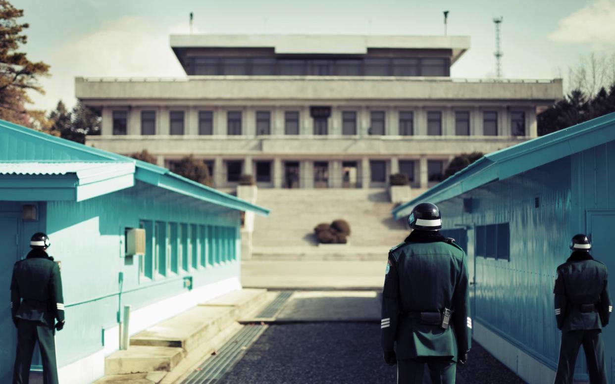
The most charged part of the DMZ is, unsurprisingly, the actual point at which the land is divided: the Military Demarcation Line, located in the Joint Security Area (JSA).
At its core is Panmunjom, which, after the Korean War ended in 1953, was designated as the one place where officials from both sides could meet. Overseen by the UN, it's the only section where forces from both sides stand face-to-face, just metres apart.
Ryall describes the scene: "Three blue huts sit astride the exact line that separates North from South, with soldiers from both sides eyeballing each other with barely concealed aggression."
In April 2018, a historic meeting between North Korean leader Kim Jong-un and South Korean President Moon Jae-in saw the two men greet each other at the Line with smiles and a hug at their first summit.
By October of last year, the JSA was cleared of its weapons, landmines and most of its guards. Currently, it is patrolled by around 35 unarmed security officials.

What do we know about the proposed hiking trails?
The $3.9million (£3m) building budget has been approved for three trails, located at central, eastern and western points of the DMZ; namely Paju, Cheorwon and Goseong. Walks will be guided, and participants will be required to wear helmets and bulletproof vests.
It is believed that visits would only be allowed between 9am and 5.30pm and that both sides will set up guard posts at the entry points to prevent defections.
And it's not open to everyone. Prospective visitors will need to enter a draw available on the South Korean Ministry of Interior and Safety and the Korea Tourism Organization's websites.
Will it be safe?
US Army General Robert Abrams, head of the UN Command on the Korean Peninsula, assures us: "South Korea's military has worked extremely long hours to ensure the success of this very important initiative, while assuring visitors their safety remains paramount."
The UK Foreign and Commonwealth Office (FCO) currently advises against "all but essential travel" to North Korea, including the DMZ.
It adds: "Since the start of 2018 there has been a renewal of direct contact between the North and South Korean governments. In the past, similar periods of diplomatic engagement have failed to be sustained."
Indeed, several violent instances have occurred at the DMZ in decades past, seemingly without warning. In 1976, two US Army officers, called into the JSA to trim a tree which was partially obstructing the view of the area from the south, were attacked and killed with an axe by two soldiers from the North.
I'm not convinced – what the next best thing?
If hiking is what you're after, you could always head a little south east of the border to South Korea's Bukhansan National Park. It featured recently in our round-up of incredibly popular tourist attractions you probably haven't heard of.

Perched on the northern outskirts of Seoul, this enclave of forests and granite peaks is an escape pod for the many citizens of the capital. It is laced with baegundae - hiking trails which tackle its high-rise mountains - and such is the level of footfall that these paths are closed on a rotated basis, to allow the soil to recover.
Inspiration for your inbox
Sign up to Telegraph Travel's new weekly newsletter for the latest features, advice, competitions, exclusive deals and comment.

